I have been accelerating my peak bagging recently to attempt completion of a Wainwright round by the end of July when I am fifty, so I was looking forward to getting a few ticks chalked up this weekend. The weather forecast was OK for Saturday, with a little drizzle possible but looking better for Sunday, so I hoped I would get plenty of walking in.
I planned a route that took in the Cockups, Meal Fell, Longlands Fell, Brae Fell and Great Sca Fell, but when I arrived in the country lane near to the start point of my route I couldn't see any easy way get access to the fell from were I had to leave the car. Checking my route it seemed possible to reverse the route heading up a bridleway towards Great Sca Fell first and end up coming back off Little Cockup, and wherever that path emerged would not be my problem, in access terms. When I designed the route I had deliberately left out Knott and Great Calva imagining myself to be tired and shagged out by the time I got near them, and not wanting to climb the highest at the end when I would frankly, my dear, not give a damn. But reversing the route meant I could do those too early on and the rest would be a fait accompli, and largely a descent to boot.
So, off I strode with one of my dogs, Jock, towards Hause Gill and Burn Tod, which I didn't intend to climb but is the first big lump I would meet on the way to Great Calva. Here's a pic of Jock running ahead up[ the lane which forms the first part of the bridleway.

This early bit steepens slightly after a quarter of a mile and hauls itself up to a rocky outcrop called Brockle Crag, which doesn't have a cairn as such, but would be a lovely place for one to rest were it not so early in the walk.

On a clearer day the view of Bakestall and Skiddaw would be very striking, but it was already seeming a bit misty as I ascended.

A little beyond Brockle Crag the path levels somewhat to the confluence of two small gills that join to make Hause Gill. I took the right of these two heading up the south flank of Burn Tod where I would eventually head more or less due south to climb up Little Calva. The Gill looking back is very pretty just where the route turns sharply south and steeply up. All that water has to go somewhere and the ground further down around the feet of Burn Tod is horribly boggy in places. By this point what had been a perfectly normal bridleway was suddenly very tricky and would be suitable only for mules and mad walkers.

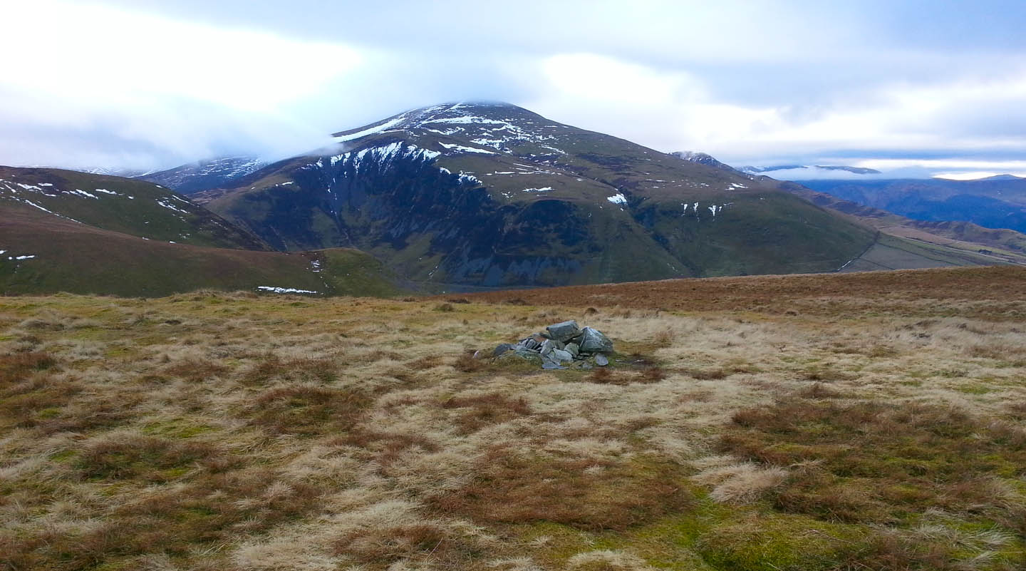
More or less as soon as I begun to climb up the now snowy slopes towards Little Calva it started to get misty and by half way I would say visibility was only a hundred yards or so. I felt pleased I have a GPS these days to help me out in mist, and it really does make a difference. I must say though that its always easier glancing at a map to get a wider appreciation of the fell with GPS helping pinpoint the current location. I often saw people on forums arguing which was best and now think the combination of the two is hugely beneficial. With the help of these tools I eventually found the "pile of stones" that the OS choose to mark on the map; not that its much to look at. As you can see, it was a hardly photo heaven by now, but as I was only using my phone for pics its always worth a snap.

Probably the worst part of the walk was next crossing the boggy morass between Little Calva and Great Calva. In clear visibility I expect its fairly clear where to go, but the absence of paths and the mist made it a "follow-a-bearing" proposition and I found myself navigating some horrible bogs and tussocks, risking a broken ankle with every others step, so deep were the concealed holes. But, I aimed-off left from the summit of Great Calva knowing I could "handrail" the fence that crosses its summit and not long after got to the foggy top. I had waded through so much snow and bog that I was beginning to feel a little moisture getting into my right boot somehow. They are supposed to have goretex lining, but nothing keeps boots completely dry forever.

The traverse North to Knott also has some boggy sections so by the time I summited it I was ready to change my right sock for a waterproof sealskin one which worked excellently, although they are not the most comfy underfoot. During the ascent of Knott which is steep five large gloomy figures had emerged only twenty paces ahead of us from the thick fog coming down. This proper put the wind up poor Jocky and he howled and legged it down hill until I called him and persuaded him to return, but he gave them a wide berth. They were all apologies and proved to be a very nice group. Poor old Jock!
By now I'm sure you have spotted a theme in these photos as its becoming a sequence of misty cairns and dog's graves. With all the fog I'm afraid there was little else to snap.

The last of the misty mountains was to be Great Sca Fell which is a short walk in gentle descent from Knott.

I think I must have yelped when the fog suddenly began to clear as I started out from Great Sca Fell towards Brae Fell. Suddenly the scene unfolded and I was able to get some kind of picture of the hills around. The whole of Brae Fell appeared golden and warm looking, though for some reason I didn't photograph that view. Nor did I take a summit shot of Brae Fell either as it was rammed with walkers unusually - the first I'd met at a summit that day.

Although I did tarry a bit on Brae Fell eating my lunch and talking to a couple of guys doing my route the other way round, I was soon off to Longlands thus requiring a long detour around the gorge between Brae Fell and Longlands which defies a direct beeline. Longlands is not a steep hill and I got briskly to the top, took the requisite pic....

...and scooted off to Lowthwaite Fell, a Birkett among the Wainwrights. there's not much on it to denote a top, but as its between Longlands and Little Sca Fell, my next destination I ploughed over it. In the end, I lazily decided to skirt around Little Sca Fell and I wish I hadn't as the path around its southern shoulder is both uneven and bouldery; not to mention requiring a crossing of a gill near a waterfall on a quite dodgy slope. I would have been better off putting five minutes of extra effort in and going over the peak to get to Meal Fell. The saddle connecting Little Sca Fell and Meal Fell is in the middle-ground of this pic.

Once on the saddle, Meal Fell is a simple stroll away and probably the most interesting top of the walk with what looks like old fortifications and a cairn....

....and an impressive wind shelter on the other side of the summit. Writer Bill Birkett speculates that the apparent quarrying is redolent of the hill fort on Carrock Fell, so it wouldn't surprise me to find this was once a fort too.

Beyond this shelter the hill drops away to the Trusmadoor Gap, here, which was the last significant ascent of the day up towards Great Cockup.

Great Cockup is deceptive. From a distance the subsidiary peak looks higher but this indistinct summit is actually a little more elevated....
....than this one. But I trudged over both anyway.

And I'm glad I did because the height gave me a good view of a lovely sunburst which made me curse not having brought my SLR camera. I reckon I could have got a great shot of this scene with my good gear, though there is some impression of the view from this phone pic.

The last half mile takes in the charming compact summit of Little Cockup...


...where a direct descent could be taken back to the start of the bridleway I took at the outset, but I chose to deviate slightly over Orthwaite Bank and got another snap of the sunburst which seemed to hang around for ages.
I contrived to slip in the last fifty yards of the path and fall arse-over-tit getting all muddy in the process but otherwise uninjured.

Back at the Travellers Rest in Grasmere, Jocky was one knackered dog, after 12 miles and 7 Wainwrights.

No comments:
Post a Comment